West Virginia State Tax Department Forms & Instructions
WV STC-1236 — Coal Producer/Operator Return Instructions
PLEASE NOTE: THESE INSTRUCTIONS ARE TO ASSIST YOU IN THE PREPARATION OF THE TAX RETURN. THEY ARE NOT A SUBSTITUE FOR TAX LAW AND REGULATIONS
# THIS RETURN MUST BE COMPLETED FOR EACH SEAM IN A PERMIT BY JURISIDICTION
Please fill the check list page out for each return filed.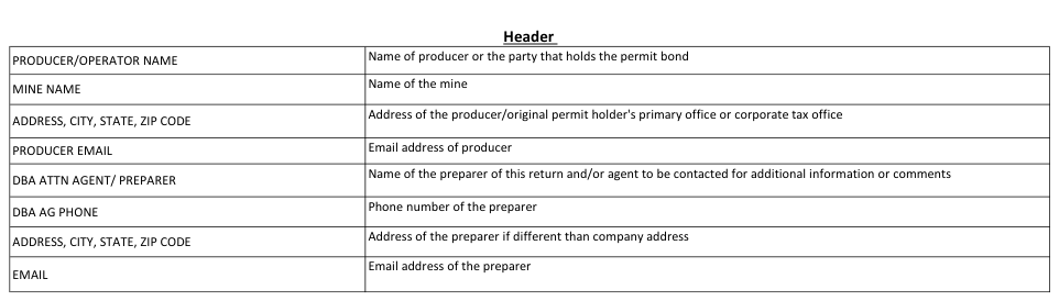
Text version of this table
PRODUCER/OPERATOR NAME Name of producer or the party that holds the permit bond MINE NAME Name of the mine ADDRESS, CITY, STATE, ZIP CODE Address of the producer/original permit holder's primary office or corporate tax office PRODUCER EMAIL Email address of producer DBA ATTN AGENT/ PREPARER Name of the preparer of this return and/or agent to be contacted for additional information or comments DBA AG PHONE Phone number of the preparer ADDRESS, CITY, STATE, ZIP CODE Address of the preparer if different than company address EMAIL Email address of the preparer
# PRODUCER EMAIL
Text version of this table
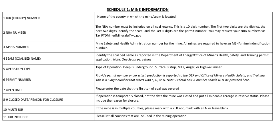
| 1 JUR (COUNTY) NUMBER | Name of the county in which the mine/seam is located |
| 2 NRA NUMBER | The NRA number must be included on all coal returns. This is a 10 digit number. The first two digits are the district, the next two digits identify the seam, and the last 6 digits are the permit number. You may request your NRA numbers via Tax PTDMinedMinerals@wv.gov |
| 3 MSHA NUMBER | Mine Safety and Health Administration number for the mine. All mines are required to have an MSHA mine indentification number. |
| 4 SEAM (COAL BED NAME) | Identify the coal bed name as reported in the Department of Energy/Office of Miner's Health, Safety, and Training permit application. Note: One Seam per return |
| 5 OPERATION TYPE | Type of Operation. Deep is underground. Surface is strip, MTR, Auger, or Highwall miner |
| 6 PERMIT NUMBER | Provide permit number under which production is reported to the DEP and Office of Miner's Health, Safety, and Training. This is a 6 digit number that starts with S, D, or U. Note: Federal MSHA number should NOT be provided here. |
| 7 OPEN DATE | Please enter the date that the first ton of coal was severed |
| 8-9 CLOSED DATE/ REASON FOR CLOSURE | If operation is temporarily closed, not the date the mine was closed and put all mineable acreage in reserve status. Please include the reason for closure. |
| 10 MULTI JUR | If the mine is in multiple counties, please mark with a Y. If not, mark with an N or leave blank. |
| 11 JUR INCLUDED | Please list all counties that are included in the mining operation. |
# SCHEDULE 2: PRODUCTION INFORMATION
Text version of this table
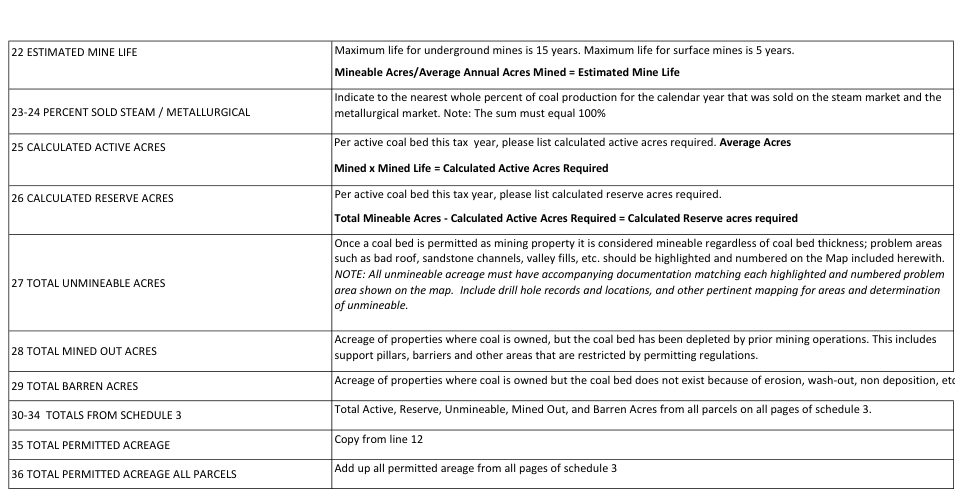
| 22 ESTIMATED MINE LIFE | Maximum life for underground mines is 15 years. Maximum life for surface mines is 5 years. Mineable Acres/Average Annual Acres Mined = Estimated Mine Life |
| 23-24 PERCENT SOLD STEAM / METALLURGICAL | Indicate to the nearest whole percent of coal production for the calendar year that was sold on the steam market and the metallurgical market. Note: The sum must equal 100% |
| 25 CALCULATED ACTIVE ACRES | Per active coal bed this tax year, please list calculated active acres required. Average Acres Mined x Mined Life = Calculated Active Acres Required |
| 26 CALCULATED RESERVE ACRES | Per active coal bed this tax year, please list calculated reserve acres required. Total Mineable Acres - Calculated Active Acres Required = Calculated Reserve acres required |
| 27 TOTAL UNMINEABLE ACRES | Once a coal bed is permitted as mining property it is considered mineable regardless of coal bed thickness; problem areas such as bad roof, sandstone channels, valley fills, etc. should be highlighted and numbered on the Map included herewith. NOTE: All unmineable acreage must have accompanying documentation matching each highlighted and numbered problem area shown on the map. Include drill hole records and locations, and other pertinent mapping for areas and determination of unmineable. |
| 28 TOTAL MINED OUT ACRES | Acreage of properties where coal is owned, but the coal bed has been depleted by prior mining operations. This includes support pillars, barriers and other areas that are restricted by permitting regulations. |
| 29 TOTAL BARREN ACRES | Acreage of properties where coal is owned but the coal bed does not exist because of erosion, wash-out, non deposition, et |
| 30-34 TOTALS FROM SCHEDULE 3 | Total Active, Reserve, Unmineable, Mined Out, and Barren Acres from all parcels on all pages of schedule 3. |
| 35 TOTAL PERMITTED ACREAGE | Copy from line 12 |
| 36 TOTAL PERMITTED ACREAGE ALL PARCELS | Add up all permitted areage from all pages of schedule 3 |
Text version of this table
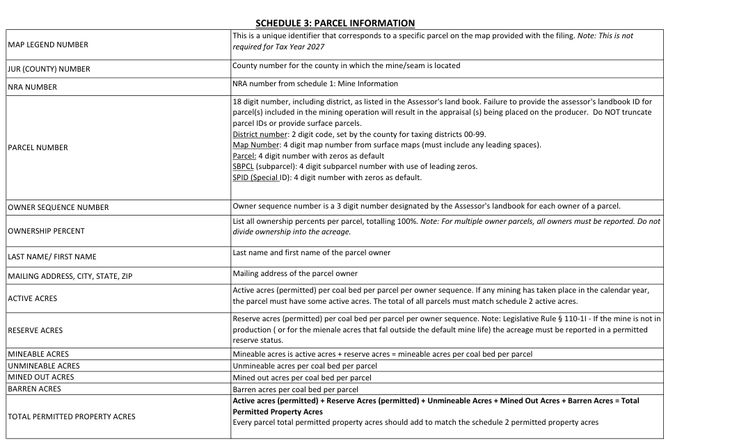
| MAP LEGEND NUMBER | This is a unique identifier that corresponds to a specific parcel on the map provided with the filing. Note: This is not required for Tax Year 2027 |
| JUR (COUNTY) NUMBER | County number for the county in which the mine/seam is located |
| NRA NUMBER | NRA number from schedule 1: Mine Information |
| PARCEL NUMBER | 18 digit number, including district, as listed in the Assessor's landbook. Failure to provide the assessor's landbook ID for parcel(s) included in the mining operation will result in the appraisal (s) being placed on the producer. Do NOT truncate parcel IDs or provide surface parcels. District number: 2 digit code, set by the county for taxing districts 00-99. Map Number: 4 digit map number from surface maps (must include any leading spaces). Parcel: 4 digit number with zeros as default SBPCL (subparcel): 4 digit subparcel number with use of leading zeros. SPID (Special ID): 4 digit number with zeros as default. |
| OWNER SEQUENCE NUMBER | Owner sequence number is a 3 digit number designated by the Assessor's landbook for each owner of a parcel. |
| OWNERSHIP PERCENT | List all ownership percents per parcel, totalling 100%. Note: For multiple owner parcels, all owners must be reported. Do not divide ownership into the acreage. |
| LAST NAME/ FIRST NAME | Last name and first name of the parcel owner |
| MAILING ADDRESS, CITY, STATE, ZIP | Mailing address of the parcel owner |
| ACTIVE ACRES | Active acres (permitted) per coal bed per parcel per owner sequence. If any mining has taken place in the calendar year, the parcel must have some active acres. The total of all parcels must match schedule 2 active acres. |
| RESERVE ACRES | Reserve acres (permitted) per coal bed per parcel per owner sequence. Note: Legislative Rule § 110-1I - If the mine is not in production ( or for the mienale acres that fal outside the default mine life) the acreage must be reported in a permitted reserve status. |
| MINEABLE ACRES | Mineable acres is active acres + reserve acres = mineable acres per coal bed per parcel |
| UNMINEABLE ACRES | Unmineable acres per coal bed per parcel |
| MINED OUT ACRES | Mined out acres per coal bed per parcel |
| BARREN ACRES | Barren acres per coal bed per parcel |
| TOTAL PERMITTED PROPERTY ACRES | Active acres (permitted) + Reserve Acres (permitted) + Unmineable Acres + Mined Out Acres + Barren Acres = Total Permitted Property Acres Every parcel total permitted property acres should add to match the schedule 2 permitted property acres |
# PARCEL NUMBER
18 digit number, including district, as listed in the Assessor's landbook. Failure to provide the assessor's landbook ID for parcel(s) included in the mining operation will result in the appraisal (s) being placed on the producer. Do NOT truncate parcel IDs or provide surface parcels.
District number: 2 digit code, set by the county for taxing districts 00-99.
Map Number: 4 digit map number from surface maps (must include any leading spaces).
Parcel: 4 digit number with zeros as default
SBPCL (subparcel): 4 digit subparcel number with use of leading zeros.
SPID (Special ID): 4 digit number with zeros as default.
OWNER SEQUENCE NUMBER Owner sequence number is a 3 digit number designated by the Assessor's landbook for each owner of a parcel.
# OWNERSHIP PERCENT
# ACTIVE ACRES
(permitted) per coal bed per parcel per owner sequence. If any mining has taken place in the calendar year, the parcel must have some active acres. The total of all parcels must match schedule 2 active acres.
# RESERVE ACRES
TOTAL PERMITTED PROPERTY ACRES
Active acres (permitted) + Reserve Acres (permitted) + Unmineable Acres + Mined Out Acres + Barren Acres = Total
Permitted Property Acres
Every parcel total permitted property acres should add to match the schedule 2 permitted property acres Quality Data Information Submit FOB spot and/or contract prices and quality information for any of the 4 catagories that apply. This is kept confidential. See the West
Virginia Legislative Rule § 110-1I-4.1.6
SCHEDULE 3: PARCEL INFORMATION
SCHEDULE 4
Tables and rate charts from the source document
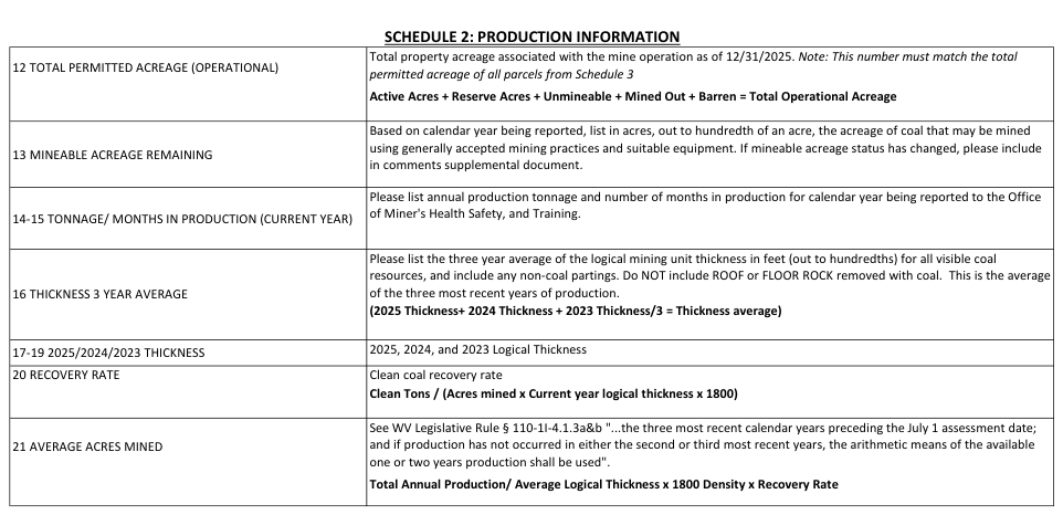
Text version of this table
| 12 TOTAL PERMITTED ACREAGE (OPERATIONAL) | Total property acreage associated with the mine operation as of 12/31/2025. Note: This number must match the total permitted acreage of all parcels from Schedule 3 Active Acres + Reserve Acres + Unmineable + Mined Out + Barren = Total Operational Acreage |
| 13 MINEABLE ACREAGE REMAINING | Based on calendar year being reported, list in acres, out to hundredth of an acre, the acreage of coal that may be mined using generally accepted mining practices and suitable equipment. If mineable acreage status has changed, please include in comments supplemental document. |
| 14-15 TONNAGE/ MONTHS IN PRODUCTION (CURRENT YEAR) | Please list annual production tonnage and number of months in production for calendar year being reported to the Office of Miner's Health Safety, and Training. |
| 16 THICKNESS 3 YEAR AVERAGE | Please list the three year average of the logical mining unit thickness in feet (out to hundredths) for all visible coal resources, and include any non-coal partings. Do NOT include ROOF or FLOOR ROCK removed with coal. This is the average of the three most recent years of production. (2025 Thickness+ 2024 Thickness + 2023 Thickness/3 = Thickness average) |
| 17-19 2025/2024/2023 THICKNESS | 2025, 2024, and 2023 Logical Thickness |
| 20 RECOVERY RATE | Clean coal recovery rate Clean Tons / (Acres mined x Current year logical thickness x 1800) |
| 21 AVERAGE ACRES MINED | See WV Legislative Rule § 110-1I-4.1.3a&b "...the three most recent calendar years preceding the July 1 assessment date; and if production has not occurred in either the second or third most recent years, the arithmetic means of the available one or two years production shall be used". Total Annual Production/ Average Logical Thickness x 1800 Density x Recovery Rate |
Source: view the official PDF
Nearby sections (14 sections)
- cit-120-instructions · WV Corporation Net Income Tax Instructions —…
- cst-200cu-instructions · WV Combined Sales and Use Tax Return…
- cst-240-instructions · WV Claim for Refund of Sales and Use Tax…
- industrial-property-return-instructions · WV Industrial Property Return…
- it-140-booklet · WV Personal Income Tax Forms and Instructions Booklet…
- it-140es · WV Individual Estimated Income Tax Payment — IT-140ES (with…
- it-141-instructions · WV Fiduciary Income Tax Return Instructions —…
- nrw-4 · WV NRW-4 — Nonresident Income Tax Agreement (composite, with…
- oil-gas-survey-instructions · WV Oil and Gas Survey Instructions…
- pte-100-instructions · WV Pass-Through Entity Tax Return Instructions —…
- schedule-heptc-1 · WV Schedule HEPTC-1 — Homestead Excess Property Tax…
- stc-1235-oil-gas-instructions · WV STC-1235 — Oil and Gas…
- stc-1236-coal-instructions · WV STC-1236 — Coal Producer/Operator…
- tsd-411-senior-citizen-credit · WV TSD-411 — Senior Citizen Tax Credit…